

Leveraging LiDAR and visual sensors, SOAR outperforms current methods by optimizing real-time scene mapping and data collection and has potential applications in urban planning, disaster response, and historic preservation.
Researchers from Sun Yat-Sen University and the Hong Kong University of Science and Technology have developed SOAR, a new system enabling drones to autonomously explore and create 3D reconstructions of real-world environments. This leverages a team of unmanned aerial vehicles (UAVs) equipped with LiDAR and visual sensors. The system’s primary innovation is its ability to combine fast scene exploration with high-quality 3D reconstruction. SOAR employs a heterogeneous fleet of drones: one “explorer” drone uses LiDAR for mapping, while additional “photographer” drones collect visual data from designated points. These viewpoints are optimized in real-time, ensuring efficient coverage of the environment. The researchers implemented several novel algorithms to improve coordination and data collection across the UAV team.

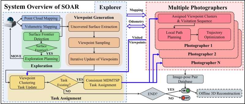
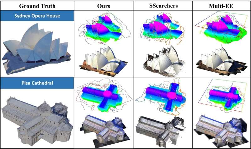
A key element of the system is its Consistent-MDMTSP method, which assigns tasks to the photographer drones, ensuring that images are captured in an optimal sequence. This approach reduces redundancy and enhances the overall reconstruction quality.The team’s simulations showed that SOAR outperformed current state-of-the-art methods in terms of speed and accuracy. The system holds promise for a variety of applications, including urban planning, infrastructure inspection, and even the preservation of historical sites. It could also prove valuable in disaster response scenarios, where rapid assessments are critical.
Looking ahead, the researchers aim to transition SOAR from simulations to real-world environments, overcoming challenges such as localization errors and communication disruptions. They are also exploring active reconstruction techniques that would allow drones to adjust their strategies based on real-time feedback, further enhancing the system’s capabilities.
“Existing methods for 3D reconstruction often either rely on detailed prior information or explore and reconstruct simultaneously but with limitations,” explained co-author Mingjie Zhang. “SOAR bridges this gap by integrating both model-based and model-free approaches, improving both speed and efficiency.”