


Innovations such as drones, robots and satellites have significantly improved the level of security of defence armed forces. In this article, we learn about the sensors within and beyond those used in the military sector.
Sensors have radically changed how we understand and interact with our world in real time. These allow us to detect data and other key performance metrics that can be analysed to get accurate information for weather forecast, automation, defence, military and aerospace.

A sensor senses changes in the environment and sends information to other electronics. Its sensitivity indicates how much its output changes when the input quantity being measured changes. In this article we talk about sensor applications in defence using remote sensing, weather monitoring, robots and drones.
Central Reserve Police Force (CRPF) has started procuring drones for tackling Maoists and terrorists. Defense Research and Development Organisation (DRDO) successfully tested Rustom 2, a heavy-duty drone. The objective of this drone is to carry out 24-hour surveillance for the armed forces.
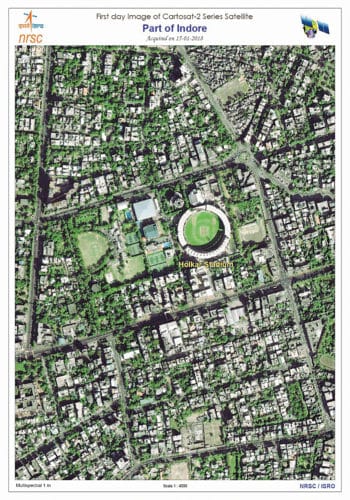
Cartosat-2 series – PSLV-C40 satellite was launched from SDSC SHAR, Sriharikota, Andhra Pradesh, on January 12, 2018 at 09:29 hours (IST). It is a follow-on mission of Cartosat-2 series with the primary objective of providing high-resolution scene-specific spot imageries. It was made by Indian Space Research Organisation (ISRO) for observating the Earth revolving in Sun’s synchronous polar orbit. The satellite carries panchromatic (black and white) and multi-spectral (colour) cameras, thus capable of delivering high-resolution data.
Remote sensing
Remote sensing can be active or passive based on the sensors used. Active sensors send light waves from their own source and measure the backscatter reflected light. On the other hand, passive sensors measure reflected sunlight (emitted from the Sun) from the objects.
Remote sensing helps defence, military and aerospace to provide different kinds of information. Navigating ships use remote sensing technologies like wind wave information, routing analysis, ship proximity along with GPS to save ships from sinking on hitting an iceberg. For searching crashed aircraft, many satellites orbit the Earth each day, collecting data that can be useful in finding lost or crashed aircraft.
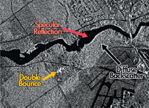
Fig. 2 is an example of active remote sensing. It may appear as just a light-and-dark pixel image. But after analysing the same, a lot of information can be found. The dark spot in the image is due to specular reflection. In this case, it shows smooth surfaces like paved surfaces or a flowing river. Double bounce backscatter waves in the image represent the bright white part in the centre. That is an urban feature like a building. Majority of the radar image is due to diffused scattering, that is, from the rough surface of vegetation growing in agricultural areas.
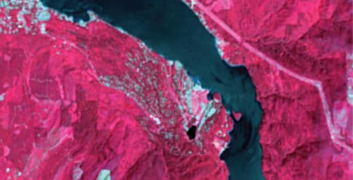
Reflected light in passive remote sensing provides images in the whole electromagnetic spectrum. For example, the multispectral image shown in Fig. 3 can have different band combinations; the bright white shows built-up areas, while the darkest shade shows water.
Integrated sensors in weather monitoring systems
India has launched many weather-monitoring satellites to monitor the weather and climate of the Earth. INSAT-3DR, the latest weather-monitoring satellite, carries Satellite Aided Search and Rescue Transponder. It picks up and relays alert signals originating from distress beacons on land, air or sea. It provides better night-time pictures of clouds and fog, and sea surface temperature can be measured with better accuracy. The satellite also estimates precipitation, cloud motion, winds, humidity, temperature, snow cover and so on. Images help capture atmospheric haze, different land cover types such as forests, croplands, deserts, inland water bodies, glaciers, grasslands, wetlands and the like in optical and thermal bands.
INSAT Meteorological Data (IMD) Data Processing System (IMDPS), operational at IMD, New Delhi, disseminates the data from meteorological satellites. All over the country many automatic weather stations (AWSes) have been installed by IMD and other agencies. IMD has also installed Automatic Rain Gauge (ARG) stations. An AWS requires different types of sensors to monitor barometric pressure, solar radiation, wind speed, wind direction, humidity, temperature, pH, conductivity, dissolved oxygen and more.
Military and satellites both utilise sunlight as a power source using solar panels. This is also a renewable source of energy. Nikhil Verma, engineer at BKC Weather System, quotes, “Kipp and Zonen has recently launched a new sensor, that is, DUST-IQ optical sensor, which helps calculate the efficiency of the solar panels while setting up a solar power plant (SPP). Analysis of the data of environmental parameters like radiations, wind speed, wind direction, temperature, relative humidity, barometric pressure and rainfall helps calculate the performance ratio of an SPP. This also helps achieve better performance and enhance the power generation of an SPP.”
Sanjay More, manager at Skymet Weather Services, says that, a tipping bucket rain gauge is the latest sensor that helps measure rainfall, as it is a crucial parameter to monitor for most applications. The latest technology is to use efficient algorithms at an AWS to validate the values or data of any measurement method, to check if it is true or false.
Topography is the main challenge in weather monitoring through satellites, so we need to establish a proper AWS to compare data with satellite information. To establish proper networking between an AWS and satellite stations, accurate information is needed. Skymet is India’s largest weather monitoring and forecast solution provider.
Military capabilities needed from sensors are day and night all-weather capability, long-range operation, rapid and large area search capability, detection of low signature targets, detection of concealed targets and so on.
Impact of smarter, sensor-enabled robots in defence
Smarter, sensor-enabled robots provide massive help in defence as these can make decisions based on sensory feedback. Advances in vision systems, force and tactile sensors, speech recognition and even olfactory receptors enable technologies for collaborative robots, advanced mobile robotics and autonomous driving. Their force-limiting capability has led to the emergence of robotic systems that can safely work alongside humans. Machine vision technology, laser scanners, and imaging and mapping software support robots are making their way into defence applications.
Amit Maheshwari, robotics software engineer at Sastra Robotics, says that, LiDAR, or light detection and ranging, sensor is in demand because of its better tracking, imaging and mapping capabilities. In future we may have robots and drones helping our armies in every area. Computer machine learning and artificial intelligence (AI) in robots are the key emerging technologies.
Maheshwari adds, sensors are beneficial to mimic human cognitive recognition in robots. These help robots in interacting with the environment and humans by creating eye-sight vision and providing touch capabilities. The main challenge is with security while controlling over-Cloud platforms and the Internet.
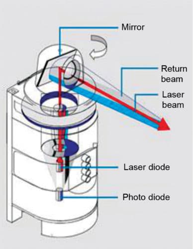
LiDAR scanner sends out its own light to interact with the object and return to the sensor. It is not affected by environmental effects like colour or sunlight. The three major criteria that differentiate most laser scanners are range, angular resolution and speed.
LiDAR shines a laser off a rotating mirror. As the mirror spins, the laser scans a viewing angle between 70 and 360 degrees, effectively creating a fan of laser light around the sensor. Any object that comes within this range reflects the laser light back to the sensor. Distance is calculated based on how long the light takes to bounce back to the sensor. Speed of light is constant and known, so the instrument can calculate the distance between itself and the target with high accuracy.
Distance of the object = Speed of light×Time taken to bounce back/2
Types of sensors
Many basic sensors in robotics help the latter perform basic functions. These are:
- A light sensor detects light and creates a voltage difference.
- Sound is detected by a sound sensor by generating a voltage proportional to sound level.
- Change in temperature provides voltage difference that is detected by a temperature sensor.
- A contact sensor triggers the desired circuit on physical contact with any object.
- A proximity sensor detects the presence of a nearby object within a given distance, without any physical contact, by analysing the return signal from interruptions.
- A pressure sensor is sensitive to touch, force and pressure.
- Approximate position of a robot is found by positioning sensors like Global Positioning System (GPS).
- An accelerometer measures acceleration and tilt. Both static force and dynamic force affect an accelerometer.
- A gyroscope measures and helps maintain orientation using the principle of angular momentum.
A new sensor technology, GelSight, has been developed by Massachusetts Institute of Technology (MIT) scientists. It is mounted on the gripper of robot arms to provide a detailed 3D map of the surface of the object in physical contact. It has given robots greater dexterity and sensitivity.
Sensors with military might. Some robots are primarily designed for explosive ordnance disposal (EOD) for military deployments. Tele-operated mobile bomb disposal robots utilise force sensors to enable operators to feel remote objects through end-of-arm force sensing and a haptic controller.
Applications of drones
Sensors embedded in an unmanned aerial vehicle (UAV) can be exposed to high accelerations and repetitive shocks, during take-off and landing, respectively. In some cases, the inertial measurement units (IMUs) are directly in contact with the outer air. A flying system is based on one crucial point: the lower its weight and power consumption, the longer it flies.
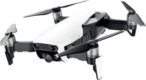
DJI Mavic air foldable drone was launched with amazing features such as 4K camera, smart gesture recognition, 3-axis gimbal, 3-dimensional obstacle detection, maximum flight time of 21 minutes with constant speed and 10km maximum flight range.
UAVs, or autonomous drones, perform tasks such as scouting, mapping, target tracking and offensive neutralising. These have the advantage of flying over medium (30 minutes) to long periods of time (up to 20-30 hours for larger units) without any need for a pilot inside. As a result, UAVs have three critical requirements: high stability during take off, navigation maneuvers and landing. These need integration of many high-performance sensors.