Global navigation satellite systems are not only becoming relevant for the economy, these are having a huge impact on the everyday lives of human beings.
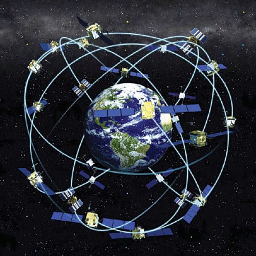
Today, we use satellites instead of stars in the sky to figure out where we are and how to get to other places. The four global navigation satellite systems (GNSSes) are the US’s Global Positioning System (GPS), Russia’s GLObal NAvigation Satellite System (GLONASS), the European Union’s Galileo and China’s BeiDou. Additionally, there are two regional systems:

Japan’s Quasi-Zenith Satellite System (QZSS), and Indian Regional Navigation Satellite System (IRNSS) or NAVigation with Indian Constellation iNavIC (both by India). iNavIC is the regional satellite navigation system of India launched and operated by Indian Space Research Organisation (ISRO). It covers India and nearby regions extending up to 1500 kilometres.
Satellites are spinning objects in an orbit in space that can tell you where you are exactly. You just need to have a GPS receiver that can pinpoint your position, to just a few metres. The GPS receiver can guide you on your way to your destination, also powered by a voice that will direct you to go left, right or straight by finding a proper route to your destination. It is a broadcast system based on radio signals that reach all parts of the Earth, and can be used by any number of people at once.
Apart from helping people reach their destination, satellite navigation systems can also help track parcels, stolen properties, vehicles and growing crops. It helps find missing persons, guide the blind, improve traffic flow and vehicle efficiency, and conduct scientific research in meteorology, troposphere and geodesy. Despite the extensive importance of GPS in everyday life, most of us do not know how it works. So, let us take a closer look.
How satellites help in navigation
All satellites are constantly beaming out radio-wave signals towards Earth from a known position, and these signals travel at the speed of light. Every signal contains information about the satellite it came from and a time stamp that informs when it left the satellite. By noting when each signal arrives, the receiver can figure out how long it took to travel and how far it has come. Each satellite carries extremely precise atomic clocks to calculate how long the signal takes to travel. If a receiver picks up a signal from three or four different satellites, it can figure out your precise location, including altitude.
GPS has three major segments:
- Space segment, which consists of a network of satellites.
- Control segment, which is a ground control network of antennae, monitors and control stations that manage the satellites, and the receiving device you carry with you.
- User segment, which is an electronic receiver you hold in your hand or carry in your vehicle.
Radio waves travel at the speed of light but only in a vacuum. These signals beaming down to us from space satellites travel through Earth’s atmosphere, including the troposphere, the uncharged region of the atmosphere and the ionosphere that contains charged particles. The troposphere and ionosphere distort and delay satellite signals in quite complex ways. So, GPS receivers have to compensate to ensure these can make accurate measurements of distance. The difference between the time it takes for the signal to be emitted by the satellite and for the satellite to receive a signal back from the receiver is tightly calculated and used to determine exactly where the receiver is located.
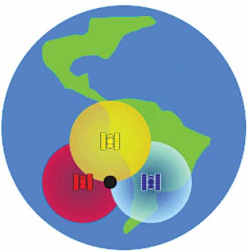
Yellow, blue and red spheres are the coverage areas of three different satellites, as shown in Fig. 1. If the receiver picks up a signal from these three satellites, it must lie somewhere at the black dot. Similarly, any object receiving a signal from any of the three satellites can be located from their meeting point. The signal from the fourth satellite will help find the altitude as well. Since there are many more GPS satellites, you can locate yourself wherever on Earth you happen to be.
Satellite-based navigation in ships
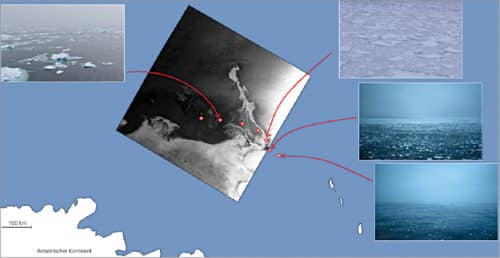
Navigation in ice-covered waters is achieved through images from radar satellites. Ice maps generated from satellite data are sent to the ships in addition to radar images. These maps make it possible to draw conclusions about ice thickness and navigability. This helps rescue teams better evaluate the immediate ice situation and avoid unnecessary detours, saving fuel. It also helps in the mapping and measuring of oceans, tides, icebergs and sea levels.
This ensures safe shipping by protecting seas and coastal waters, and assisting public authorities to combat unlawful activities such as hazardous substance dumping, illegal fishing and piracy.
New processors have been developed that can generate ice maps directly after acquisition of satellite images. These can determine the location and extent of various types of ice. To do this, complex data comprising image features that escape the human eye are analysed. Other processors are being developed to pave the way for detailed insights into the movement of sea ice in high-resolution images of ice floes.
Synthetic aperture radar (SAR)
This technology can generate images from a moving platform, regardless of light and clouds. A SAR sensor is an active system that carries an illuminator with it to sense in the dark. It uses microwaves that have wavelengths much larger than visible light. Because of that, SAR signals can penetrate through clouds and semi-transparent materials like ice, snow, vegetation, etc.
There are different types of SAR. If the radar transmits and/or receives in two different polarisations—horizontal and vertical—it could help retrieve false-colour images instead of just black-and-white data. This is called polarimetry, and it can be used for precision farming or for water bodies monitoring in floods, among others.
Another option is to acquire images from slightly different angles, in a technique called interferometry, which provides 3D vision.
Combining multiple interferometric sets of images acquired at different times is called differential interferometry, and it can be used to extract information about the deformations suffered by objects over time. Examples of this can be subsidence studies in urban areas, stability in open-pit mines and a building’s thermal expansion and contraction, volcanoes and earthquakes, among many others.
If many images of the same area are taken from different angles, tomographic techniques can be applied. SAR tomography can be used to see the inside of a forest or a glacier by sending signals to it from a satellite. This can be used, for instance, to study the amount of biomass on Earth or the inner ice layers in the North Pole.
Location-based services by satellites
This technique includes personalised marketing offers delivered to the user of the smartphone. Offers are based both on personal preferences of the user as well as on the location where the potential customer finds himself, at the moment when the offers are placed. It provides the user with information and the ability to advertise about nearby businesses and services.
This technique is also used by tourists and hikers to locate amusement parks, museums and commercial centres, among others.
The technique can provide precise time and synchronise ground-based clocks to monitor the energy flow within their own power grids. The high quality of time synchronisation provides better services for the transportation and distribution of energy. Signals provided by navigation satellites may also be utilised to measure the changes occurring in the Earth’s magnetic field caused by ionosphere storms. The research concerning the impact of ionosphere storms greatly expands human knowledge on ionosphere dynamics related to the activities of the Sun.
This is an invaluable asset for coastguards and border control authorities, as it ensures faster search and rescue operations, saving more lives. In such situations, the SAR transmitter sends an emergency positioning signal that is received by the satellites, allowing for quick and accurate emergency response. It helps respond to distress signals in case of an emergency. Marine seismic exploration is benefitting from surveys of new sites and identification of geomorphologic risks in drilling activities.
Location-based services by satellites help improve atmospheric measurements, including level of water vapour in the air, which is crucial information for more accurate weather forecasting and a better understanding of climate change. It also helps study the ionosphere and space weather, earthquakes’ predictor events, and better understand the movement of animal populations.
Highly accurate and reliable signals play an important role in fleet management, delivering the vehicles’ positioning on a map in aviation, maritime, rail and even pedestrian traffic.
Location-based services by satellites assist in monitoring from a structure’s planning to its ongoing maintenance and surveillance. The telecom industry uses timing signals for network management, calibration of frequency references, and time-tagging-certified timestamps that are necessary for electronic banking, financial transactions, e-commerce, and quality assurance systems and services.
Why we need satellite navigation systems
To save some power, devices switch on GNSS chipset periodically and keep it switched off most of the time. This is a good approach if you do not need to know the location of your device often. A GNSS chipset takes a while to come up with a good solution because it needs to collect several samples. Once it has done that, it continues to deliver good-quality results unless you reach your destination. But if you periodically turn off the chipset, you lose every time the information you had gathered before, and you cannot expect to have good results at all.
GNSSes are becoming more and more important. Not only are these becoming relevant for the economy, these are having a huge impact on the everyday lives of human beings. The aforesaid solutions serve a number of purposes related to transportation or positioning. Using multiple systems also promises to make satellite navigation much faster; if more satellites are in view, initial delay from satellites in downloading data it needs to start calculating your position is reduced. Although, it is still difficult to get signals while working under bridges and in tunnels.