


Geographical positioning system (GPS) is a very common term in today’s communication world. It is often used synonymous to satellite navigation (satnav) systems. What many of us do not realise is that GPS is a brand name that became a proprietary eponym over years, like how we say Walkman for handheld radio cassette players. There are other satellite navigation systems that provide positioning capabilities just like GPS. Let us take a look at each one of these and compare their features. Starting with…
Global Positioning System (GPS)
In the 1970s, the US Department of Defence (DoD) started the system for military purposes. It became fully-operational in 1995 and is currently used in both military and civilian applications. The GPS currently offers unlimited access to its services to civilians all over the world. Out of the 31 operational satellites, 24 satellites are placed in the medium Earth orbit (MEO) in such a way that there are at least six satellites in the receiver’s view at any point of time. The inactive ones can be reactivated whenever required. A GPS signal in space will provide a worst case pseudo range accuracy of 7.8 metres. Better accuracy is attained by clubbing it with an augmentation system.

GLObal NAvigation Satellite System (GLONASS)
Originally known as the Global’naya Navigatsionnaya Sputnikovaya Sistema, this project was started by the former Soviet Union in the 1970s for military applications. After the disintegration of the Soviet Union, it was fully recovered and restored by Russia in 2011 and the government has been promoting it for civilian use. It has an accuracy of 20 metres in civilian and 10 metres in the military signal. The system consists of 31 MEO including 24 operational, one in preparation, two on maintenance, three reserves and one under testing.
Doppler Orbitography and Radio-positioning Integrated by Satellite (DORIS)
These fully-operational regional navigation systems by France have receivers on satellites, rather than on ground stations, to pick up signals emitted by the ground-based radio beacons. Its accuracy is in the range of a few centimetres. DORIS is targeted at civilian applications. DORIS receivers are present in altimetry satellites TOPEX/Poseidon, Jason 1 and Jason 2, and in Envisat, SPOT, HY-2A and CryoSat-2.
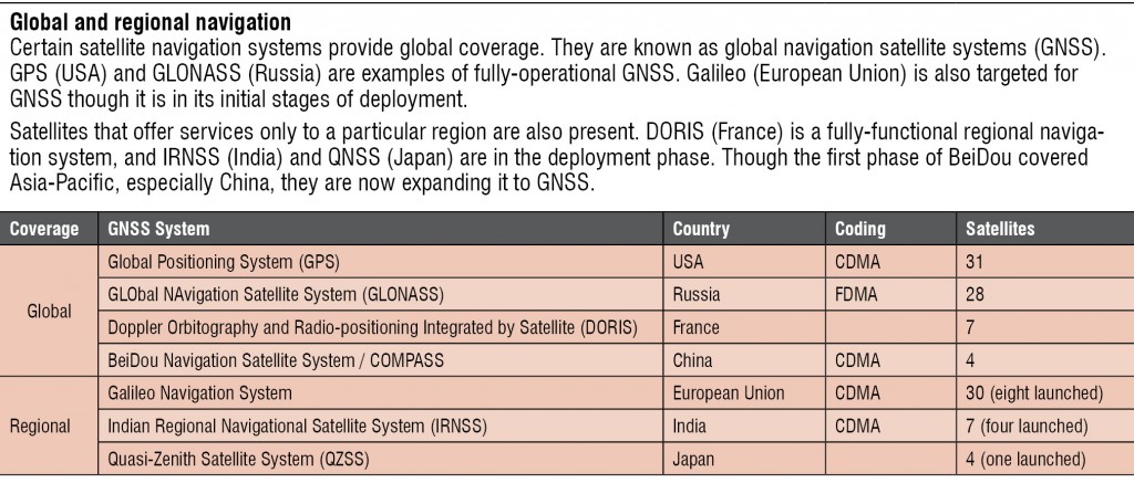
BeiDou Navigation Satellite System (BDS)
The first edition of this project, named as BeiDou-1 and launched in 2000, had three satellites, covered only China and neighbouring regions, and offered limited applications. By 2012, it was expanded to include the whole of Asia-Pacific with 16 satellites. The second generation of BDS, known as COMPASS or BeiDou-2, pitches global coverage by 2020 with five geostationary orbit (GEO) satellites and 30 MEO satellites.
Galileo Navigation System
With eight test-bed MEO satellites in orbit and 22 operational MEO satellites budgeted, the European Space Agency’s version of GPS, primarily for civilian use, is expected to be completely operational by 2020. It would be compatible with the modernised GPS (GPS Block IIIA) system. The Galileo receivers would combine the signals from both Galileo and GPS satellites to increase the accuracy of the system.
Indian Regional Navigational Satellite System (IRNSS)
The development of the IRNSS was spurred by the USA denying GPS data to the Indian military during the Kargil war in 1999. The proposed system by the Indian Space Research Organisation (ISRO) consists of a constellation of seven GEO satellites, four of which (IRNSS-1A, IRNSS-1B, IRNSS-1C and IRNSS-1D) are already placed. The remaining three satellites (IRNSS-1E, IRNSS-1F and IRNSS-1G) are proposed to be launched by May 2016. It would cover the Indian subcontinent and around 1500km around it, and serve both civilian and military (encrypted) applications.
Quasi-Zenith Satellite System (QZSS)
QZSS would augment GPS by improving the availability, and increasing the accuracy and reliability of GPS signals. It uses three satellites 120-degrees apart in slightly elliptical, geosynchronous orbits known as the quasi-zenith orbit, and would cover almost the whole of Japan including the urban canyons and mountain terrains. It is targeted at mobile communication and positioning purposes. MICHIBIKI, the first QZSS satellite was launched in 2010, and the next two satellites are expected to be operational by 2017.
The author is a dancer, karaoke aficionado, and a technical correspondent at EFY. Find her on Twitter @AnuBomb.
